name
the name nefriheyi comes from waptokan 'ŋùhièf šìhai žy', meaning 'land of the mountainous island', referring to the landmasses associated with nefrih, previously thought to be the largest non-continental island. eastern vazeheyi and the other landmasses near it were often grouped with nefrih during the age of colonisation as landmasses that were not considered large enough to form their own continent, despite eastern vazeheyi later turning out to be both larger than nefrih and connected to vazeheyi.
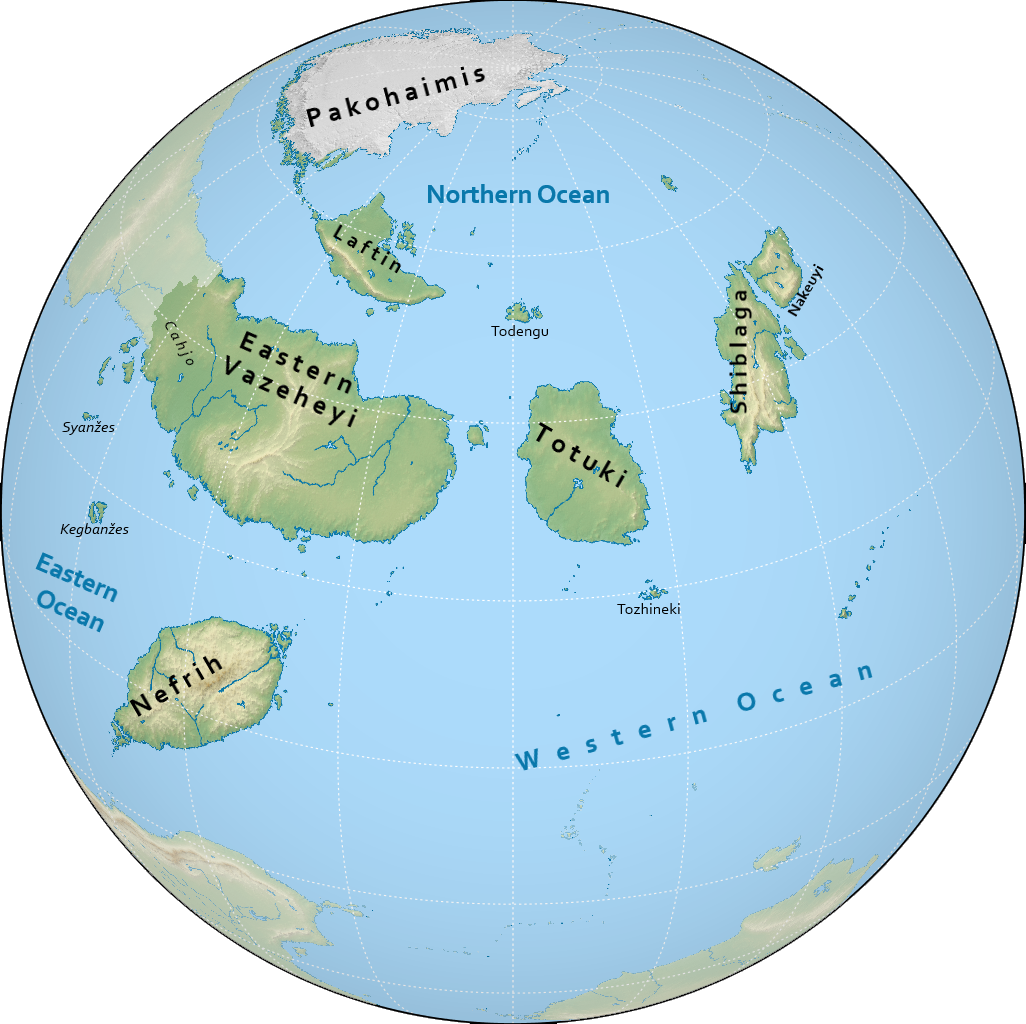
geography
nefriheyi is the third largest continent on notasami at 27 million square kilometres. it is made up of various large islands as well as the eastern half of the landmass of vazeheyi. the south of the continent meets with the western ocean, much of the north of the continent is found within the northern ocean, and the southwestern edges of the continent are bounded by the eastern ocean. the border between western and eastern vazeheyi roughly follows the 130th meridian east.
the inclusion of eastern vazeheyi is nowadays controversial and somewhat dated; contrary definitions of continents often lump nefriheyi as part of vazeheyi in fact.
climate
the climate of nefriheyi is extremely varied, owing to its wide geographic distribution.
the islands of laftin and pakohaimis experience a cold, arctic climate. laftin is mostly tundra with a more temperate southern coast while pakohaimis contains the largest icecap on notasami, as well as the geographic north pole.
totuki is three parts temperate, subtropical, and arid, from north to south.
eastern vazeheyi is very arid, with a more humid and temperate northern coast.
šiblaga and nakeuyi are mountainous and mostly temperate.
nefrih is mountainous and tropical, with a rainforest at the southern tip.
countries & territories
| flag | name | population | area |
|---|---|---|---|
| tobavega | 46,075,907 | 859,269 km² | |
| (tbd) | - | - |
history
the history of nefriheyi is usually divided into the following periods:
- prehistory: before 650
- classical period: 650 to 1200
- postclassical period: 1200 to 1700
- colonial period: 1700 to 2050
- modern period: 2050 to 2300
- interstellar period: 2300 to present
most societies in nefriheyi have been hunter-gatherers or nomads in the case of eastern vazeheyi, even up to the early modern period, with the exception of several agrarian societies in totuki, šiblaga, and in various other locations.
the first complex societies can be seen in this period, namely in tobavega and kebijes in nefrih. around this time one can also see the spread of the oškew along the southern coast of eastern vazeheyi, eventually connecting tobavega and kebijes in trade, and founding several polities on the coast.
this period sees the polities of the oškew start to wane in favour of newer indigenous powers, for instance the cahjoxa, now deeply influenced by the oškew's presence and trade. this period also sees the flourishing of various societies in šiblaga.
this period sees most of nefriheyi dominated under the rule of powers from emiheg, most importantly zohtim. despite this, tobavega remains an important player in the region, and the oškew still hold much commercial influence.
this age sees the colonies of nefriheyi gain independence from the empires of emiheg, some through struggle, and some peacefully.
this recently-defined period starts with the discovery of interstellar travel and examines the role of the countries of nefriheyi in the now accessible interstellar domain.
demographics
languages
there are around 875 languages spoken in nefriheyi, some 620 of which are found on nefrih alone. the vast majority are native to the continent, most prominently tobavegan, but the languages that see the most widespread use are all foreign. the largest language is zohti, spoken all across eastern vazeheyi, on pakohaimis and laftin, the southeast of totuki, in central-eastern shiblaga, and in northwestern nefrih. the second most widely used language is anachek, spoken in all of nakeuyi, most of shiblaga, southern totuki, and southeastern nefrih. the next most important group is the oshkew languages, having migrated from vazeheyi all across the southern shore and some inland regions of eastern vazeheyi. some mesne is also spoken in the southern tip of nefrih.
religion
nefriheyi is home to myriads of native religions and customs, which have unfortunately been greatly diminished in the past few centuries as a result of colonialism. overall, bunapunism is the most widespread faith. in the south of nefrih, the dominant faith is terenism, while along the southwestern coast of eastern vazeheyi, lonca lishexa calga is widely practiced.
population
the most populous country in nefriheyi is tobavega with 46 million people. most countries in nefriheyi have populations over 1 million people, and twelve countries have more than 10 million people.
the largest metropolitan areas in nefriheyi include kamelšav, monggkzoṭi koget, and xilukxen. the three of these have populations exceeding 10 million people, making them megacities.