name
the name emiheg comes from the ancient waptokan word 'heèmiŋaiak' meaning "south", referring to much of the continent being situated to the south of yafu. it originally applied to the area of xesfar and over time the meaning spread to cover the whole continent.
geography
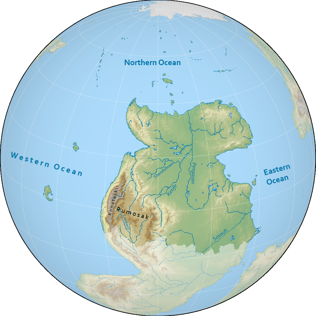
north emiheg is the second largest continent on notasami at 31 million square kilometres, making up the northern half of emiheg, the largest landmass on notasami. the continent is surrounded by the eastern ocean to the east, the northern ocean to the north, and the western ocean to the west. the border between north and south emiheg is usually roughly considered to follow the southern edge of the rumosak plateau and the sosauh river.
climate
the climate of north emiheg ranges mostly from tropical to arid and subtropical.
the western coast of north emiheg is particularly less tropical as a result of its altitude with the konataskir plateau displaying an almost subarctic climate.
much of the low-lying interior consists of a savannah which culminates in the largest rainforest on notasami to the south, the sosauh forest.
yafu on the other hand, is mostly desert in the interior, with its coastal areas being more humid.
countries & territories
| flag | name | population | area |
|---|---|---|---|
| zohtim | 344,121,123 | 3,561,154 km² | |
| gutonim | 221,039,772 | 2,133,202 km² | |
| (tbd) | - | - |
history
the history of northern emiheg is usually divided into the following periods:
- prehistory: before -3000
- bronze age: -3000 to -780
- dalassan period: -780 to 109
- postclassical period: 109 to 1125
- low period: 1125 to 1688
- early modern period: 1688 to 2050
- modern period: 2050 to 2300
- interstellar period: 2300 to present
most of the interior had been inhabited mainly by nomadic pastoralists, with many groups of hunter-gatherers in more forested areas. agriculture seems to have been most commonly practiced along the western and eastern coasts.
this age is known primarily for the kingdom of xesfar, one of the earliest civilisations on notasami.
this era is centered around the dalassan empire, which conquered much of northern emiheg and has left a lasting legacy on the world. this era also sees the emergence of bunapumism, the largest religion on notasami.
this period follows the collapse of the dalassan empire. a period of significant upheaval, it sees the emergence of several new kingdoms vying for control and waves of migrations of peoples from the south. significant polities include the tsifatsic kingdom and the zohtim empire.
this age follows the fracturing of zohtim, resulting in a period of more marked decline and stagnation. southern migrations culminate in the genreme empire reaching far into the north. the turmoil in the interior sees the less affected polities of yafu looking elsewhere for trade, triggering a wave of exploration beyond emiheg.
this period sees most of northern emiheg recovering and entering a cultural and scientific renaissance. global exploration triggers a wave of global colonisation and imperialism, most notably by gutonim and zohtim. for more minor powers, advances in science and philosophy test traditional modes of governance.
in this age the colonial powers of north emiheg now try to keep their empires under their own control, but thanks to still-exponentially increasing scientific progress, their colonial possessions gradually slip away.
this recently-defined period starts with the discovery of interstellar travel and examines the role of the countries of north emiheg in the now accessible interstellar domain.
demographics
languages
north emiheg is home to several language families and isolates. over 500 languages are estimated to be spoken, most notably including anachek and zohti. major language families include konataskiran in the west, yafukan in the northeast, farxariman in the centre, and kunafkan in the southeast.
religion
the vast majority of north emiheg follows kekataki bunapumism. irreligious people form the second largest proportion, and the third are kanma bunapum mainly in the southwest. berumaki bunapumism can also be found alongside the southern edge of the continent, and various other denominations of bunapumism are found all across, mostly in yafu.
there are also several minorities as a product of recent migration from ex-colonial regions, chief among them terenism and keridism.
population
the most populous country in north emiheg is zohtim with over 344 million people. all countries in north emiheg have populations over 1 million people, and eleven countries have more than 100 million people.
the largest metropolitan areas in north emiheg include hanete, nakif, and sirui. the three of these have populations exceeding 15 million people, and seven more have more than 10 million people, making them megacities. hanete is the second largest urban area in notasami.