name
the origin of the name pogalaki comes from its namak name 'pōgelaki', most likely meaning "ashen", referring either to its deserts or volcanic activity.
geography
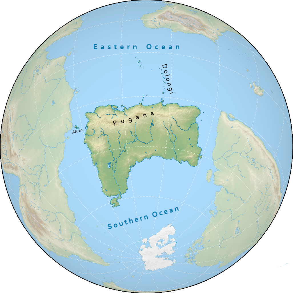
pogalaki is the second smallest continent on notasami at 14 million square kilometres, located between emiheg and rundanuyi. the continent is surrounded by the southern ocean to the southwest and the eastern ocean to the northeast, separated from rundanuyi by the strait of rundanu.
climate
pogalaki is a mostly arid continent.
the north coast is dominated by the pugana mountain range, which hosts some more humid, temperate areas.
the southwestern coast of pogalaki is also relatively temperate, transitioning to a more subarctic climate at the southern tip.
the dolongi island chain to the north is also considered to be part of pogalaki. the islands are tropical and many are humid, hosting various rainforests.
countries & territories
| flag | name | population | area |
|---|---|---|---|
| niloyi | 54,366,206 | 1,295,623 km² | |
| (tbd) | - | - |
history
the history of pogalaki is usually divided into the following periods:
- prehistory: before 0
- tacane period: 0 to 680
- kunesu period: 680 to 1060
- low period: 1060 to 1732
- colonial period: 1732 to 2050
- modern period: 2050 to 2300
- interstellar period: 2300 to present
most prehistoric sites on pogalaki are distributed along the north and west coasts, where the climate is more hospitable, allowing for various agrarian societies to have emerged, while the interior of the continent has mostly seen nomadic pastoralists.
this age starts with the migration of the totsane tribe onto atuza and then the mainland, founding the tacane kingdom. this period also saw the founding of bembusa and oklus in the east, the former of which would rival and eventually overshadow the tacane.
this era starts with the earliest documented occurrence of the kunesu, who would soon go on to establish a nomadic empire that subdued most of pogalaki. over time, coastal powers gradually manage to overcome their rule as the kunesu become more sedentary, until the empire's breakup in 1060.
after the waning of the kunesu empire, pogalaki sees a period of relative stagnation and turmoil. no one power really becomes a consistant hegemon.
this age sees most of pogalaki dominated under powers from emiheg. the soikem empire remains the only native polity to resist colonisation.
this age sees the colonies of pogalaki gain independence from the empires of emiheg, some through struggle, and some peacefully.
this recently-defined period starts with the discovery of interstellar travel and examines the role of the countries of pogalaki in the now accessible interstellar domain.
demographics
languages
the three most important language families native to pogalaki are the pevechelan and bembusan families along the northern coast and the kunesu languages in the interior. in the southern half of the continent anachek dominates as the most widely spoken language, and to a lesser extent kerzan, though many minority languages are still spoken. it is estimated that there are some 140 languages spoken in pogalaki.
religion
the northern coast pogalaki is dotted with several ancient denominations of bunapunism, having gradually spread from emiheg during the tacane period. similarly, terenism has also managed to spread into pogalaki, mostly on the northeastern coast. in the interior and the west, the indigenous kunesu faith is highly dominant.
in the south, kekataki bunapunism is most prevalent thanks to colonialism, and in the southwest southern bunapunism in particular also has a significant presence.
population
the most populous country in pogalaki is niloyi with over 54 million people. all countries in pogalaki have populations over 1 million people, and ten countries have more than 10 million people.
the largest metropolitan areas in pogalaki include lupas, petumsuris, cal, and malpapi. the four of these have populations exceeding 5 million people.