name
the name emiheg comes from the ancient waptokan word 'heèmiŋaiak' meaning "south", referring to much of the continent being situated to the south of yafu. it originally applied to the area of xesfar and over time the meaning spread to cover the whole continent.
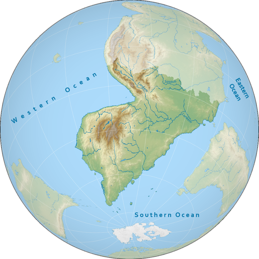
geography
south emiheg is the fourth largest continent on notasami at 25 million square kilometres, making up the southern half of emiheg, the largest landmass on notasami. the continent is surrounded by the western ocean to the northwest, and the southern ocean to the southeast. the border between north and south emiheg is usually roughly considered to follow the southern edge of the rumosak plateau and the sosauh river.
climate
the climate of south emiheg is mostly arid and subarctic.
the northern border ranges from subtropical to temperate, the latter due to mountainous terrain.
the low-lying eastern half has an arid interior, surrounded by subtropical coasts.
the western half is very mountainous: from low to high altitudes the climate ranges from arid to temperate to subarctic.
the southern coast is dominated by tundra, with taiga in the interior.
countries & territories
| flag | name | population | area |
|---|---|---|---|
| bizoyi | 195,624,737 | 8,656,958 km² | |
| histatinyi | 168,341,789 | 1,722,774 km² | |
| loraneyi | 292,705,261 | 1,049,877 km² | |
| (tbd) | - | - |
history
the history of southern emiheg is usually divided into the following periods:
- prehistory: before -1500
- bronze age: -1500 to 0
- northerner period: 0 to 700
- great migration: 700 to 1400
- aftermath of the genreme: 1400 to 1732
- early modern period: 1732 to 2050
- modern period: 2050 to 2300
- interstellar period: 2300 to present
agrarian societies seem to have been common all along the northern coast, with hunter-gatherers in the south and nomads in the interior. agriculture has also spread from north emiheg southwards along the eastern coast.
this age sees most of its activity along the northern coast. the first major society, the lostor culture, emerged sometime around -1500, and by around -500 the kudunem start spreading around meksu.
this period starts when the dalassan empire makes its way to meksu and, briefly, occupies the northern half of the coast of the gulf. from here in dalassan meksu would emerge bunapunism, what would eventually become the largest religion on notasami. around this same time in the northeast the kunafkan tribes emerge, overruning dalassa and gradually migrating more to the south. the latter half of this period is dominated by semesku and kansetasa.
around 700 a number of the nomadic peoples of the interior migrated northwards into central emiheg, causing great instability. these migrating groups mostly took the place of elites and integrated quickly, leaving little cultural or linguistic traces. the most important of the kingdoms formed by these peoples included the kōlamso and the lomson, which would bring an end to the tsifatsic kingdom up north. still, kunafkan migration kept going to the south, bringing rise to the lonkem and bizowka. the west sees several kingdoms come and go after semesku fell as a result of the migrations, with few clear powers rising to any similar statures for long.
in the early 1400s the genreme empire explodes northwards from the central steppes of south emiheg, ravaging much of the continent. it would fracture into several squabbling hordes not 50 years later, despite leaving most of the continent on its knees. several previously less successful polities could now gain power by chipping away at the remnants of the genreme, some of which including the kloranem, lemcigu, and eventually bizoyi. the east was not affected much by the genreme, and the region started to stabilise.
this period sees some of southern emiheg taking a minor part in the cultural and scientific renaissance of the north as new advancements gradually diffused south. global exploration triggers a wave of global colonisation and imperialism, with loraneyi colonising overseas to the east all the way to rundanuyi, and bizoyi conquering much of the interior and the entire southeastern coast, and eventually both would split the northeastern corner of southern emiheg amongst themselves. the east is mostly politically stagnant save for some minor wars, and is technologically catching up with much of the rest of the continent albeit at a glacial pace.
in this age the two major colonial powers of south emiheg now try to keep their empires under their own control, but thanks to still-exponentially increasing scientific progress, their colonial possessions gradually slip away. conversely, to the north of meksu, histatinyi unites, formerly a set of city states that had spent the last 800 years fighting one another, consequently becoming a minor power in the region.
this recently-defined period starts with the discovery of interstellar travel and examines the role of the countries of south emiheg in the now accessible interstellar domain.
demographics
languages
the two main language families of south emiheg are the katawan family and the kunafkan family. histatin is also a major language in the north, but the rest of the histatinan languages are usually considered to be located in north emiheg. numerous smaller indigenous families may also be found. it is estimated that over 300 languages are spoken in south emiheg.
religion
the largest religion in south emiheg is southern bunapunism, found throughout the interior and southeastern coast. in the centre, around meksu, sioros is the dominant faith, and along the border with north emiheg berumaki bunapunism dominantes, especially in histatinyi. traditional folk religion is common along the northwest coast, and irreligion is also common, especially in the northeast and around loraneyi.
population
the most populous country in south emiheg is loraneyi with over 290 million people. all countries in south emiheg have populations over 1 million people, and eight countries have more than 100 million people.
the largest metropolitan areas in south emiheg include yonkobo, putecu, kezewag, qassomaki and pomolon. the five of these have populations exceeding 10 million people, making them megacities.